
Smartphone RTK
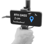 With theory and practice, we can quickly get you to the point of using the Smartphone RTK Device effectively and economically in professional applications.
We show you everything you need for everyday projects.
Included in this are subjects such as the image recording strategy, geo-referencing and quality control using control points GCPs. Data transfer and editing for your other CAD and GIS software products.
With theory and practice, we can quickly get you to the point of using the Smartphone RTK Device effectively and economically in professional applications.
We show you everything you need for everyday projects.
Included in this are subjects such as the image recording strategy, geo-referencing and quality control using control points GCPs. Data transfer and editing for your other CAD and GIS software products.3D ImageVector
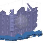
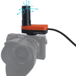 New to direct georeferencing using RTK/PPK camera add on in terrestiral photogrammetry or 3D documentation?
Well, we get you productive in a short time. We teach you practical things and enough theoretical background to understand the workflow and get started with your first projects.
New to direct georeferencing using RTK/PPK camera add on in terrestiral photogrammetry or 3D documentation?
Well, we get you productive in a short time. We teach you practical things and enough theoretical background to understand the workflow and get started with your first projects.Beginner / Advanced Photogrammetry Trainings
 With theory and practice, we can quickly get you to the point of using photogrammetry effectively and economically in professional applications. Whether you are taking photos with your new drone, or use a hand-held camera for capturing facades, we can show you everything you need for everyday projects.
Included in this are subjects such as the image recording strategy, geo-referencing with control points or an RTK/PPK system, the selection and operation of software, and data transfer and editing for your other CAD and GIS software products.
Seminar for Photogrammetry Experts
 Would you like to get more out of your data? Are you unsure if the results are accurate? Is your photogrammetry workflow or processing too slow? Together we can find solutions and exploit the full potential of your photogrammetry software. Point-cloud classification, orthophoto enhancement, and accuracy and quality assessment are covered, as well as flight planning and recording strategy, camera settings, and anything else that may help to optimise your work. The content is tailored to your needs!
Individual Seminar
 Your already know the basics, we will help you to go a step ahead by offering you a seminar program tailored on your needs and goals. Get in touch with us to know more
Agisoft Metashape
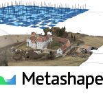
As a distributor of Agisoft Metashape, we provide training and support for this software package. Ask for either group or individual training. We integrate the software into your full project workflow, allowing you to get the most out of your data.CloudCompare - Pointcloud enhancements
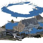
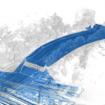 Many people simply use CloudCompare as viewer, which is really a pity, because this wonderful software has many powerful features which you you will quickly appreciate in your daily tasks. We are happy to train you in point cloud filtering and classification, producing terrain models (DTM), multi-temporal point cloud analysis, rendering, producing videos and more.
QGIS for UAV Pilots
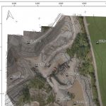 Do you want to create PDF maps of your results? QGIS is an open source geographic information system (GIS) with which you can perform everything from forrestry analysis to volume calculations, and export the results with a title block, captions and a north arrow. We provide training tailored to your needs and empower you to deliver results to your customers.
QGIS Volume calculation Tool
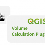 We have recently developed a new Volume Calculation Plugin for QGIS. It is available and open source on git hub.